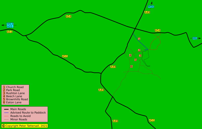
With most people having satnav, there’s little to be gained from various detailed directions. It is the final few miles where a little advice can be an aid to confidence. In the case of Oulton Park, that advice can also include the avoidance of roads unsuitable to towing vehicles, as in the red-marked roads in the above map.
Oulton Park is located midway between Chester and Junction 18 of the M6. Consequently, that is the route most travellers are expected to take. It takes around 25 minutes to drive west, along the A54, to the A49 turn off.
From the Northwest
Travelling from the Northwest is usually via Junction 10 of the M56. From here it is around 20 minutes, always on the A49, until crossing the A54 and joining the above M6 route.
From the West
From the West, again join the A54, turning right at the A49.
0.25 mile after crossing or leaving the A54, turn right into Coach Road.
From the South
For southern visitors travelling via the A49, I recommend staying on the A49 as it cuts into the A51 and heads north. From there, it is 4.5 miles to the Coach Road turn off, to the right. An alternative is the 3.7 mile to the circuit route that takes in Eaton Lane, Beech Lane and Park Road. I’ve only driven a little along this route, from the Oulton Park entrance, before deciding that it is less suitable. From the turn into Coach Road, it is about 1.25 mile to the junction for Park Road, where our directions proper start for each of the entrances.
Entrances
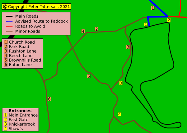
There are four entrances to the circuit, all explained next, with the main entrance described first and in detail.
Having crossed or turned off the A54, it is only a third of a mile to the left-turn into Coach Road. Care should be taken along this country road, especially as it is mainly straight and narrow. Another 1.25 miles brings one to a junction that requires a very sharp right turn. Opposite this junction can be seen, ahead, the East Gate entrance. On turning right and having travelled and extra 0.2 mile, we come across the Main Entrance. This entrance is the most likely entrance to be open. Depending on the event, some or all of the remaining entrances will be closed.
For the Knickerbrook Entrance, carry on for less than a fifth of a mile, before turning right into Rushton Lane.
Shaw’s entrance confuses me as it doesn’t look like a public access point, but references on the internet indicate that it is. Those references include Oulton Park’s and MSV’s own pages. Contacting Oulton Park direct wasn’t an uplifting experience and so I shall provide the details and leave the reader to decide. To get there, continue past the Knickerbrook Entrance for another third of a mile, then turn left. The entrance is a quarter of a mile down this lane.
Main Entrance
This is the competitor’s entrance and leads directly to the paddock. It is the entrance that I have based the directions on. The remaining entrances will be described with this Main Entrance being the starting point.
East Gate
Unless told otherwise, it is best to consider this as a pedestrian only entrance, only available during very popular events. I have never known it to be open.
If following the recommended route at the start of this guide, the drive will see this entrance opposite the junction at the end of Coach Road.
Knickerbrook Entrance
From the end of Coach road, turn right into Park Road, Continue past the Main Entrance, and continue for less than a fifth of a mile. Turn left into Rushton Lane, which is very narrow. The entrance is another half mile down, on the left.
Shaw’s Entrance
I’m not confident that this is an entrance, especially as it is via a very narrow lane that looks private. I shall hold off providing directions until I am confident.
SatNav
Entering the post code into my satnav usually gets me there, but not always, so I also include GPS coordinates. What3Words are also an increasingly useful addition. I try to find a w3w location with at least one word that is related to motor racing; I also try to find short words.
I have also provided coordinates and What3Words for a position within the paddock. This could be useful as a meeting point for guests.
Coordinates
Coordinates are given in the three formats:
- DMS: Degrees, Minutes, and Seconds
- DD: Decimal degrees
- What3Words
Circuit Entrance Coordinates
- DMS: 53°11’0.96″,-2°37’3.93″
- DD: 53.1836011545724,-2.61775726863236
- What3words: ///clenching.reset.trailer
Paddock Coordinates
- DMS: 53°10’47.11″,-2°36’52.01″
- DD: 53.179752,-2.614448
- What3words: ///hydration.betraying.paddock
Paddock

Having entered the circuit via the Main Entrance, drive straight on until the Chequers Restaurant is directly ahead, then turn left.
Buy the PDF
This Getting There page is available as a downloadable PDF at a very reasonable price. Click the thumbnail to view it in the store.
A Complete Guide of this venue is also available, which includes all of the above guides. Click the thumbnail to view it in the store.
You can also click this thumbnail to view all the available PDFs in the shop.
Page updated by Peter Tattersall, August 2025


